Is the UK still in Europe? What’s the difference between Scandinavia and the Nordic countries? Looking at a clear Map of Europe can quickly make these geographic questions much easier to understand. If you’ve ever felt a little lost during a news report or a conversation about geography, you’re not alone.
Map of Europe Explained: Countries, Regions, Cities & Capitals
Europe can seem like a complex puzzle, and this common confusion makes it tough to follow world events, plan a trip, or just feel confident in your knowledge of the world.
The secret to making sense of the sprawling map of Europe isn’t trying to memorize dozens of countries at once. Instead, the key to mastering European geography is to think of the continent in terms of logical, bite-sized regions.
It’s less about a long list and more like learning the distinct neighborhoods of a giant, fascinating city, where each area has its own character and a core group of countries that are easy to remember together.
By walking through the continent region by region, we can put the puzzle pieces together in a way that actually makes sense.
You’ll be able to identify major areas, name their key countries, and finally solve those tricky geography questions. Let’s build your mental atlas, one step at a time.
First, Let’s Zoom Out: Where Is Europe, and How Is It Organized?
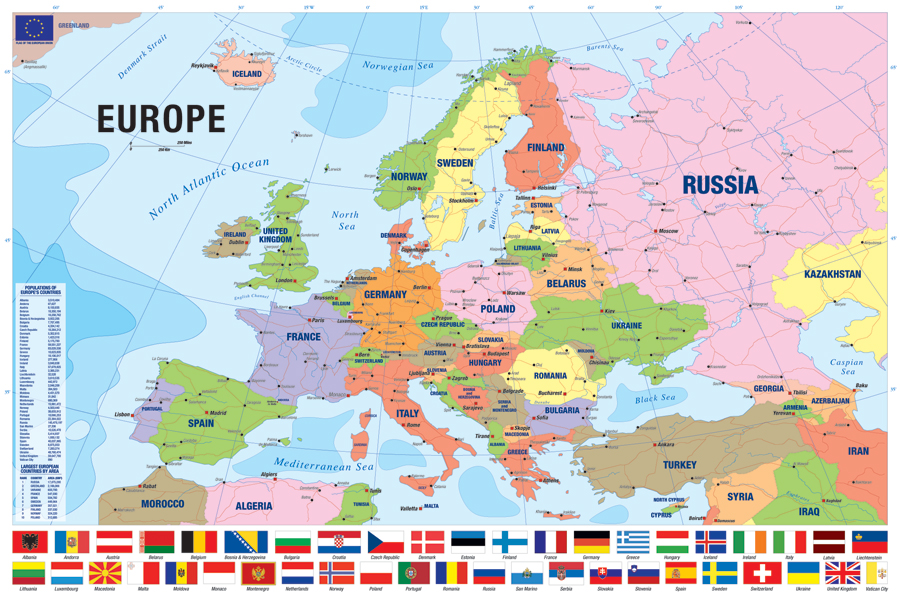
Looking at a full map of Europe can feel overwhelming—a dense cluster of over 40 countries, each with its own borders and capital. Geographically, Europe is a large peninsula extending west from the massive landmass of Asia. Its boundaries are mostly defined by water: the Arctic Ocean to the north, the Atlantic Ocean to the west, and the Mediterranean Sea to the south. The traditional dividing line between Asia and Europe in the east is formed by the Ural Mountains in Russia.
The most effective way to understand this crowded map is to group the countries into broad regions that share similar locations and, often, historical ties. This approach turns one giant puzzle into four smaller, more manageable ones. By learning the regions first, you create a mental filing cabinet to easily store and locate individual countries later on.
The most common model uses four regions:
- Western Europe: Often seen as the continent’s economic core.
- Northern Europe: Home to the Nordic and Baltic states.
- Southern Europe: The countries lining the warm Mediterranean coast.
- Eastern Europe: The vast region stretching toward Asia.
With this simple framework in mind, the political map of Europe becomes much clearer as we explore the countries that make up each distinct area.

Exploring Western & Central Europe: The Continent’s Economic and Travel Hub
When many people picture a classic European trip, they’re often imagining the countries of Western Europe. This region, anchored by powerhouses like France and Germany, has long been a global center for culture, industry, and finance. It’s also where you’ll find a few smaller but equally important nations. On a map of Europe, countries like Austria and Switzerland are perfectly positioned as a geographic bridge between the west and east, which is why they are often grouped into a region called Central Europe.
Within this area lies a special group known as the Benelux countries. This isn’t a single country, but a nickname for three small, densely populated neighbors who formed a close economic partnership: Belgium, the Netherlands, and Luxembourg. Think of them as a tight-knit trio at the continent’s crossroads, with Brussels, the capital of Belgium, even serving as the main headquarters for the European Union.
Because these nations are centrally located and share borders with many others, they serve as major hubs for travel and trade.
A drive from Paris to Berlin, for instance, showcases just how connected this region is. The key countries that make up this bustling core of Europe are:
- France (Paris)
- Germany (Berlin)
- Austria (Vienna)
- Switzerland (Bern)
- Belgium (Brussels)
- Netherlands (Amsterdam)
- Luxembourg (Luxembourg)
What Are the Nordic & Baltic Countries? A Tour of Northern Europe
Europe’s northern reaches are a region of stunning natural beauty, from dramatic fjords to vast forests. This is where you’ll hear the terms “Scandinavia” and “Nordic,” which are often used interchangeably but actually mean different things. Getting the distinction right is a simple way to boost your geographic confidence.
At its core, Scandinavia refers to the three kingdoms of Denmark, Norway, and Sweden, which share closely related languages and a Viking heritage. The term Nordic Countries, however, is a broader cultural and geographical family. It includes all of Scandinavia plus Finland and Iceland.
- Scandinavia: Denmark (Copenhagen), Norway (Oslo), Sweden (Stockholm)
- The Nordic Countries: All of Scandinavia, plus Finland (Helsinki) and Iceland (Reykjavík)
Just south of Finland, hugging the coastline of the Baltic Sea, lies another important trio: the Baltic States. These three nations—Estonia, Latvia, and Lithuania—are often grouped together because of their similar geography and shared history. After regaining their independence from the Soviet Union in the early 1990s, they have emerged as modern, tech-savvy members of the European Union.
Sun, Sea, and History: Getting to Know Southern Europe
The map of Southern Europe is dominated by lands lapped by the sparkling Mediterranean Sea. This region is characterized by its large peninsulas—big arms of land that jut out into the water. The two most prominent are the Iberian Peninsula in the southwest, which is home to Spain and Portugal, and the famous boot-shaped Italian Peninsula. These landforms give the region its iconic coastlines, which have been central to trade and culture for thousands of years.
Looking closer at the map of Italy reveals a geographical curiosity. Tucked right inside the city of Rome is Vatican City, the smallest independent country in the world.
This is a perfect example of a microstate, a sovereign nation that is exceptionally small in both area and population. Moving eastward across the sea from Italy, you’ll find Greece, a nation of thousands of islands whose own peninsula forms the southern tip of the larger Balkan Peninsula.
Together, countries like Spain, Portugal, Italy, and Greece form the core of what many imagine when they think of a classic European getaway. While they each have unique cultures, their shared Mediterranean geography and ancient roots.
Unpacking Eastern Europe: A Region of Diverse Cultures
The Balkan Peninsula, which we glimpsed with Greece, anchors a region where Southern and Eastern Europe meet. This mountainous landmass in Southeast Europe is home to a mosaic of countries, including Croatia, Serbia, and Albania.
The term “Balkan” often brings to mind a complex history, and for good reason—this area has long been a crossroads of major empires and cultures, making it one of the most diverse corners of the continent. Understanding this peninsula is a key piece of the puzzle when looking at the map of Europe.
Beyond the Balkans, the map of Eastern Europe extends north to include large nations such as Poland, the Czech Republic, and Ukraine. While often grouped together, this is not a single, uniform bloc. From the medieval cities of Prague and Krakow to the Black Sea coast, the region is a tapestry of distinct languages, traditions, and landscapes. The borders here have shifted more than in any other part of Europe, reflecting a turbulent but resilient history that has shaped the continent.
For many people, the term “Eastern Europe” is still linked to the Cold War era. However, the last few decades brought dramatic change. Many nations in the region are now vibrant, independent democracies, increasing how many countries are in Europe today.
A large number of them have also joined the European Union, which is a political and economic partnership. This distinction between the continent of Europe and the EU is a common source of confusion.
Solving Europe’s Biggest Puzzles: EU vs. Schengen vs. The UK
One of the most common points of confusion is the difference between “Europe” and the “European Union.” Think of it this way: Europe is the continent—the physical landmass stretching from Portugal to the Ural Mountains in Russia.
The European Union (EU), on the other hand, is a political and economic “club” of 27 member countries located on that continent. Switzerland and Norway, for example, are geographically in Europe but are not members of the EU.
Adding to the mix is the Schengen Area, which is all about easy travel. This is an agreement between 29 countries to act as a single zone for international travel, with no passport or border controls at their mutual borders. It’s like a giant neighborhood where you can walk from one house to another without showing an ID. The members of the Schengen Area and the EU are not identical; for example, Ireland is in the EU but not the Schengen travel zone, while Iceland is in the travel zone but not the EU.
Another classic puzzle is the difference between the UK vs Great Britain, which is simple when you break it down.
- Great Britain = This is the name of the main island, which is home to three countries: England, Scotland, and Wales.
- The United Kingdom (UK) = This is the official sovereign state. It includes the island of Great Britain plus Northern Ireland.
Understanding these layers is key to reading a modern map and making sense of the news. Knowing the difference between the European Union vs Europe continent helps you understand politics, while knowing about Schengen helps you plan a trip.
How to Actually Learn the European Map: 2 Simple Practice Tools
Just staring at a completed map isn’t the best way to make the information stick. The most effective learning trick is to test yourself. After studying a region, try to recall the countries and their locations from memory. This simple act of pulling information from your brain, rather than just reading it, is the key to building a strong mental map and labeling a map of Europe without frustration.
To put this method into action, your best friend is a printable blank map of Europe for practice. Don’t try to label everything at once. Instead, focus on one region you just learned, like the Iberian Peninsula, and try to label Spain and Portugal from memory. Check your answers, then move on to the next region. Breaking the continent into small pieces makes the task feel manageable instead of overwhelming.

Once you’re feeling more confident, you can turn practice into a game. Many websites offer a free interactive map of Europe for students and curious adults.
These fun quizzes challenge you to find countries and capitals against the clock, quickly solidifying your knowledge. A few rounds of a game can reinforce what you’ve learned far better than hours of passive reading.
Putting Your Knowledge into Practice
That cluttered map of Europe, once a jumble of unfamiliar names and borders, is now a place you can navigate with confidence. You’ve moved from seeing a puzzle to understanding the picture, grasping where countries fit and why. This new mental map is a powerful tool you can use every day.
The best way to learn European geography is by breaking it into manageable pieces: the distinct regions of the West, North, South, and East. Now, when you hear about “Scandinavia” or the “European Union,” it won’t be a vague concept. You’ll have a clear framework, knowing exactly where and what people are talking about.
To make this knowledge stick, try this: the next time a country is mentioned in a movie or the news, find it on a map. Notice its neighbors and which region it belongs to. With the concepts of Europe explained, the map is no longer an intimidating test, but an open invitation to continue your discovery.


